FOR REAL ESTATE IN CROATIA ISTRIA CLICK HERE. TO RENT HOLIDAY ACCOMMODATION IN ISTRIA CLICK HERE. FOR TOPADRIA CHARTER GO HERE. FOR EVENTS IN CROATIA ISTRIA CLICK HERE. TO DOWNLOAD A DETAILED BROCHURE ABOUT ISTRIA CLICK HERE.
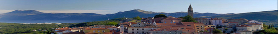
Istria is indeed a feast for the eyes. Its streams flow to the sea through deep valleys and gullies which bring to mind the ancient local myths about giants. Rolling hills overlook the fields and valleys with little towns perched on the peaks, recalling some old paintings. The view is splendid: white-topped mountains, lush wheat fields, plateaux, valleys, vineyards and olive groves on hillsides, and, finally the sea.
As you get to know Istria you will notice more and more enchanting details: church facades and portals, tiny village alleyways with their specific architectural touches, the babble of a stream, the blossoming cherries. Everything is warm–hearted and friendly here: nature, towns and people. Main destinations (see links for further details): Brioni National Park, Buzet, Grožnjan, Labin, Medulin, Motovun, Novigrad, Opatija (Kvarner), Pazin, Poreč, Pula, Rabac, Rovinj, Umag, Vodnjan, Vrsar. To read an interesting article about Istria go here.
2012 Event Calendar
FACTS Location
The westernmost county of the Republic of Croatia. The largest peninsula of the Adriatic.
Area
2,820 km2 (triangle Dragonja, Kamenjak, Učka)
Population
206,344
Language
Croatian
Coast Length
445 km (well-indented coast is twice as long as the road one). The western coast of Istria is 242.5 km long, with island 327.5 km.
The eastern coast of Istria is 202 km long with the pertaining islets 212 km.
Sea
The lowest sea temperature is in March ranging from 9.3°C up to 11.1°C. The highest sea temperature is in August when it reaches 23.3°C and 24.1°C. Salinity amounts approximately to 36-38 pro mille.
Rivers
Mirna, Dragonja and Raša
Vegetation
Istria is the largest green oasis of the North Adriatic. The coast and the islands are covered with pine woods and easily recognizable green macchia. The main specimens of macchia are holm oak and strawberry trees. 35% of Istria is covered with forests.
Administrative Centre
Pazin (9,227 inhabitants)
Economic Centre
Pula (58,594 inhabitants)
For accommodation in Istria click here. For real estate in Istria click here. For other information about Istria visit www.istra-istria.hr. | | IMMOBILIEN IN ISTRIEN FINDEN SIE HIER. URLAUBUNTERKÜNFTE IN ISTRIEN GIBT ES HIER. TOPADRIA CHARTER FINDEN SIE HIER. VERANSTALTUNGEN IN ISTRIEN SEHEN SIE HIER. EINE DETAILLIERTE BROSCHÜRE ÜBER ISTRIEN FINDEN SIE HIER.
Mit einem Blick können Sie die Mannigfaltigkeit Istrien's erfassen, von dem Schneeweiß der nahen Berge, dem Wogen der grünen Wiesen und Felder, Ebenen und Senken, von den Wellenförmigen Landschaften mit Weinbergen und Olivenhainen bis zum klaren Blau des nahen Meeres.
Wenn Sie diese Pracht betreten, wenn Sie ihr ganz nah kommen, wird Sie mit jedem ihrer Details bezaubern, mit jeder Einzelheit: Kirchenportale und Stadttore, Dorfstrassen mit Höfen, Rundbögen und offenen Treppenhäusern, das Gurgeln rauschender Bäche und Lichtungen blühender Kirchbäume. Alles ist hier so vertraut und freundschaftlich: die Natur, die Siedlungen und die Menschen. Hauptdestinationen (siehe Links für weitere Details): Brijuni Nationalpark, Buzet, Grožnjan, Labin, Medulin, Motovun, Novigrad, Opatija (Kvarner), Pazin, Poreč, Pula, Rabac, Rovinj, Umag, Vodnjan, Vrsar. Einen interessanten Artikel über Istrien finden Sie hier
Veranstaltungskalendar 2012
FAKTEN
Geographische Lage
Westlichste Region der Republik Kroatien, größte Halbinsel der Adria
Fläche
2 820 km2 (Dreieck: Dragonja, Kap Kamenjak, Učka)
Bevölkerungszahl
206.344 (2001.)
Küstenlänge
445,1 km (die vielfältige Küste ist doppelt so lang wie die Küstenstraße). Die Westküste Istriens ist 242,5 km lang, mit den Inseln 327,5 km (178,1 M). Die Ostküste Istriens ist 202,6 km lang, mit den dazugehörigen Inselchen 212,4 km (114,5 M).
Meer
Die niedrigste Meerestemperatur ist im März und liegt zwischen 9,3°C und 11,1°C und die höchste im August ind liegt zwischen 23,3°C und 24,1°C.
Der Salzgehalt des Meeres beträgt 36 – 38 Promille.
Flüsse
Mirna, Dragonja und Raša
Vegetation
Istrien ist die größte grüne Oase der Nordadria. Entlang der Küste und auf den Inseln gibt es vorwiegend Kiefernwälder und die typische grüne Macchia. Die wichtigsten Pflanzenarten der Macchia sind die Steineiche und der Erdbeerbaum. Die Wälder in Istrien bedecken 35% der Fläche.
Verwaltungszentrum
Pazin (9 227 Einwohner)
Wirtschaftszentrum
Pula (58 594 Einwohner)
Unterkünfte in Istrien finden Sie hier. Immobilien in Istrien gibt es hier. Weitere Informationen über Istrien finden Sie bei www.istra-istria.hr. |